Geospatial: Mapping India’s Progress with Smarter Insights
March 21, 2025 | Deep Dives


 Follow
Geospatial computing is transforming how we analyze and interact with spatial data, driving innovations across industries through advanced technologies like AI, IoT, and cloud services.
What is Geospatial Computing?
Geospatial computing is the science and technology of acquiring, analyzing, visualizing, and managing geographic information. It's about understanding the "where" and using that knowledge to solve complex problems. This involves a synergy of technologies:
- Satellite Imagery: Capturing Earth's surface from space.
- GPS (Global Positioning System): Determining precise locations.
- GIS (Geographic Information Systems): Platforms for managing and analyzing spatial data.
- Sensors: Devices that collect location-specific data.
These components integrate to create detailed digital representations of physical spaces, from sprawling urban centers to remote natural landscapes. Geospatial computing is not just about maps; it's about unlocking insights hidden within location data.
The field of spatial computing, a subset of geospatial computing, is gaining prominence. Technologies like Apple's Vision Pro and Meta Quest are bringing spatial computing to the forefront, demonstrating a significant shift in how we interact with digital information and the physical world. This surge in spatial computing is creating new avenues for partnerships and growth for companies specializing in geospatial solutions.
Geospatial Industry Value Chain
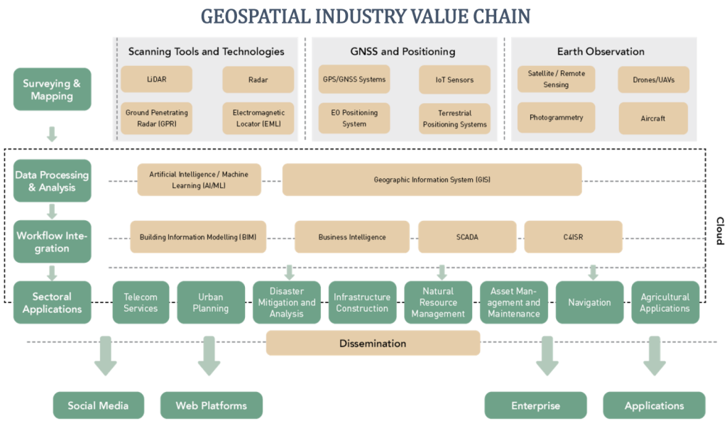
(Source- GW CONSULTING REPORT)
The Geospatial Industry Value Chain represents the various processes and technologies involved in capturing, processing, analyzing, and disseminating geospatial data.
Key Components of the Value Chain:
- Scanning Tools and Technologies: These tools are used to collect geospatial data from various sources, such as satellites, drones, aircraft, and ground-based sensors. Examples include LiDAR, radar, ground-penetrating radar, and electromagnetic positioning systems.
- GNSS and Positioning: This component refers to the Global Navigation Satellite System (GNSS), which provides accurate positioning information. GNSS systems like GPS are used in a wide range of applications, from navigation to surveying and mapping.
- Earth Observation: This component encompasses technologies like satellites and drones that are used to capture images and data of the Earth's surface. These data are then used for a variety of purposes, such as monitoring environmental changes, disaster management, and urban planning.
- Data Processing and Analysis: This component involves cleaning, processing, and analyzing geospatial data to extract meaningful insights. This may involve using Geographic Information Systems (GIS) software, as well as other advanced technologies such as artificial intelligence and machine learning.
- Workflow Integration: This component focuses on integrating the various processes and technologies in the value chain to create a seamless workflow. This can be achieved through the use of workflow management software and other tools.
- Sectoral Applications: This component highlights the various sectors that benefit from geospatial technologies. These sectors include telecommunications, urban planning, disaster mitigation, infrastructure construction, natural resource management, asset management, navigation, and agricultural applications.
- Dissemination: This component refers to the process of sharing geospatial data and information with end users. This can be done through a variety of channels, such as social media, web platforms, and enterprise applications.
Why Geospatial Computing Matters Now?
1) Exponential Industry Growth
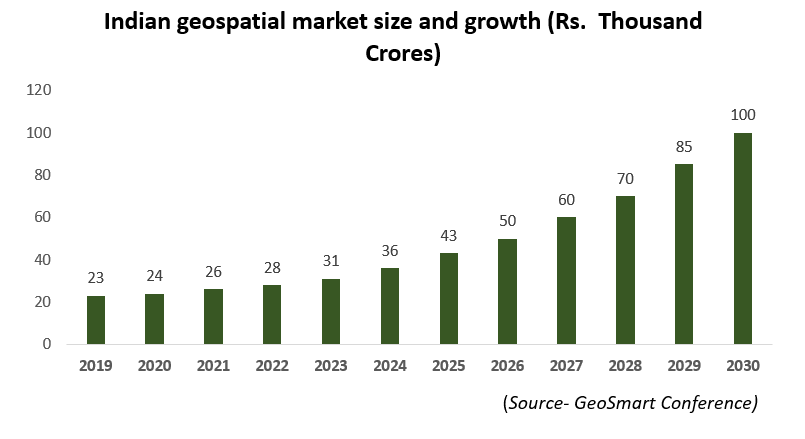
- The National Geospatial Policy, 2022, along with the government's emphasis on infrastructure growth, positions India's geospatial sector for long-term expansion. The market is projected to grow from Rs. 30,000 crores in FY24 to Rs. 1 trillion by FY30, reflecting a CAGR of approximately 22%. This includes domestic opportunities worth Rs. 63,000 crore and an export market valued at Rs. 37,000 crore
- The policy has reshaped the industry’s trajectory by establishing accuracy standards for foreign entities, fostering a regulated environment that safeguards domestic players, restricts foreign competition, and enhances opportunities for Indian companies. With growing government support, increasing recognition of geospatial technology across various sectors, and emerging applications, the industry is set for sustained growth.
- Major corporations like L&T and Reliance are acquiring geospatial firms, signaling long-term confidence in the technology.
2) Avoiding Costly Errors
- Example: Mumbai’s Andheri bridge misalignment could have been prevented with geospatial planning tools.
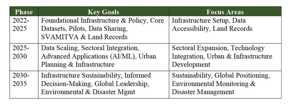
3) Government Vision and Policy support
- India aims to create a complete 3D map of the country by 2030, enabling smarter infrastructure and environmental management.
- Goals as mentioned under the National Geospatial Mission, 2022:
4) Geospatial Technology in Action: Indian Case Studies
India is leveraging geospatial technology to address a variety of challenges and drive development:
4.1 Agriculture
- eNAM (Electronic National Agriculture Market): This initiative integrates GIS and IoT to optimize crop prices and supply chains, benefiting farmers and consumers.
- Other applications include the Kisan Portal, Soil Health Card Scheme, and PM Kisan Samman Nidhi Yojana, which utilize geospatial data for agricultural planning and management.
4.2 Governance
- SVAMITVA Scheme: This scheme uses drones to map rural properties, helping to resolve land disputes and provide clear property ownership records.
- Geospatial technology is also used in e-District Services, e-Registration of Property, and Online Mutation of land records.
4.3 Healthcare
- eSanjeevani: This telemedicine service leverages location data to connect patients with healthcare providers, improving access to medical care, especially in remote areas.
- Other applications include the National Digital Health Mission (NDHM) and Ayushman Bharat Digital Mission (ABDM), which utilize geospatial data for healthcare planning and delivery.
4.4 Environment
- Namami Gange Program: This program uses geospatial sensors and analytics to monitor pollution levels in the Ganges River, supporting efforts to clean and rejuvenate this vital waterway.
- Geospatial technologies also support Digital Forest Health Monitoring Systems and Carbon Credit Project Registration.
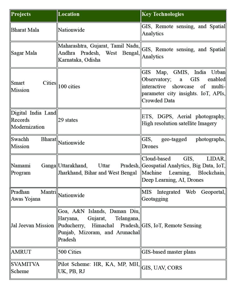
Geospatial Applications in National Mission Programs
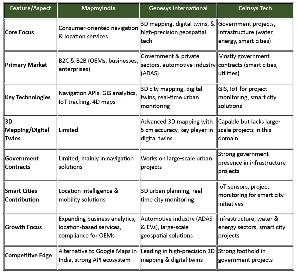
Industry Players
Let's break down the key differences between Genesys, Ceinsys, and MapmyIndia. This comparison will give you a clear understanding of their business models, focus areas, and how they operate within the geospatial industry. By analyzing these distinctions, you’ll gain valuable insights into the sector and the role each company plays in shaping its future.
The Road Ahead: Trends and Future Outlook
The future of geospatial computing is dynamic, with several key trends shaping its trajectory:
Consumer Technology Integration
- The integration of geospatial technologies into consumer products like Apple Vision Pro and Meta Quest is expanding the reach and applications of spatial computing, bringing its benefits to a wider audience.
Private Sector Expansion
- The increasing involvement of the private sector in developing geospatial solutions for various industries, including logistics, retail, and more, is driving innovation and creating new market opportunities.
India as a Geospatial Talent Hub
- India is emerging as a key hub for geospatial talent, with companies like Trimble establishing major offices in the country, reflecting confidence in India's skilled workforce and the sector's growth potential.
Conclusion
Geospatial computing is a transformative force, reshaping how we understand and interact with the world. From preventing infrastructure failures to improving access to healthcare and enabling sustainable environmental management, its applications are vast and impactful. As technologies continue to advance and the private sector plays a greater role, geospatial computing is poised for continued growth and innovation, promising a future where location intelligence drives smarter decisions and a better world.
Disclaimers and Disclosures
SEBI Registration No. :INH000017338, IN/AIF3/24-25/1571, IN/AIF2/24-25/1607 | BASL Membership ID: 6276
Investment in Securities Market are subject to market risks. Read all related documents carefully before investing. The securities quoted are for illustration only and are not recommendatory. Registration granted by SEBI, membership of a SEBI recognized supervisory body (if any) and certification from NISM in no way guarantee performance of the intermediary or provide any assurance of returns to investors.
